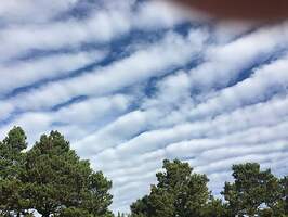
Best guess, altocumulus undulatus clouds.
you gotta love clouds
Dan,
I see those all the time up here in Western Wisconsin. Usually after a cold front goes through and the high pressure following it, later in summer and early fall by my best recollection.
I wonder if these are also what are called cloud streets?
Dale.
One of these days I’m going to set up my camera to do a time lapse. The discussions in weather texts for them is that clouds ‘roll’ along, with the undulation you mention. If that is what happens, they should appear on one side and disappear on the other as the air undulates or if it is rolling, sort of like a rolling pin coming into and going out of view if you are the pie dough.
On the other hand, when I’ve had a chance to watch them, it seems as if they are a self contained cloud, like a puffy little fair wx cloud again in high pressure, with it being as stable as a cloud of that kind can be, and just moves across the land.
As late October approaches, chances for any interesting clouds diminish until spring.
I noticed these clouds “moved” across the sky and did not appear to change shape. Almost like a contrail, they formed and then drifted. I always try to imagine what kind of air mass would it take to form cloud shapes…just boggles the mind trying to figure these things out. Anyways, I thought they were interesting and worth posting…
For sure ![]()
there would have been a uniform up and down motion (wave) that created those clouds …i.e like ripples in the sand
This topic was automatically closed 180 days after the last reply. New replies are no longer allowed.
