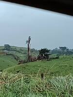
gusts to 160kmh here tonight!
(87 knots, 100 mph)
will be a lot of trees down and buildings damaged
Wow - is that from Cyclone Keni?
no, although there was likely some energy related to (ie a bit like a twinning), as that hurricane was due north of us (Fiji)
it was a wave depression that got an energy boost from a very cold airflow straight from antartica and from a sting jet over it and from warmer than normal ocean temperatures (still 20c)
Wow! Looks like you really took a beating. Story and pics here: https://watchers.news/2018/04/10/severe-storm-snow-and-tornadoes-wreak-havoc-across-new-zealand/
Good link Harry ![]() Certainly looks like real weather
Certainly looks like real weather ![]()
NZ trucker driving in tornado Terrifying footage as Kiwi drives through tornado | Newshub
Another article. Looks like you are going to get hit again. I hope the next one isn’t as bad.
[size=83]A powerful storm that hit Auckland, New Zealand on April 10, 2018 left widespread damage and an 'unprecedented' 200 000 properties without electricity. In addition, cell phone network was severely damaged, leaving many citizens without service. Another front is expected to move rapidly up New Zealand on April 12, bringing a few thunderstorms and a short, sharp spell of strong winds. A watch has been issued for Auckland and Northland tomorrow evening. [/size]
will not be as bad the next one
I think this was one was as bad as it was due to a Sting Jet associated with the low
Also the low was very fast moving and so that increased the windspeed (analogy is like throwing a ball out the window of a moving train)
Raining right now, we are getting the reminates of Huracane Rosa which came up the Baja gulf and is no affecting the south west. Forecast is a flood watch.
FLASH FLOOD WATCH NOW IN EFFECT THROUGH LATE TUESDAY NIGHT… The Flash Flood Watch is now in effect for * A portion of south central Arizona… * The remnants of Hurricane Rosa along with a follow-on system will lead to scattered to numerous showers and thunderstorms at times this afternoon through Tuesday night over Arizona and southeast California. Conditions are favorable for localized flash flooding during this time frame. For most areas, the most likely time-frame for flash flooding will be Monday night through Tuesday night. * Locations in the Watch area that are most likely to experience flash flooding will be poor drainage areas and normally dry washes near higher terrain. A Flash Flood Watch means that flooding of washes, creeks and other drainage areas is possible within the watch area. If you are in the watch area, you should watch the weather and be prepared to take immediate action should heavy rain and flooding occur or a flash flood warning be issued.
