Feedback from a couple of far northern users (Finland and northern Canada) have me wondering about the snow algorithms in WXSIM. These (effect of albedo changes, melting, etc.) are something I researched very carefully, on multiple occasions (using 25-30 years of data for a few different U.S. sites), and I already take into account tree cover to some extent, but too-low temperatures for these northern sites have me wondering if the effect of dark-colored trees (fir, for example) is greater than I had thought. Even with snow on the ground, a dark-colored forest can absorb a lot of sunlight, and this might account for the too-cold bias for these sites.
Any feedback on this? I’m also wondering about snow cover effects in general.
I notice that WXSIM predicts faster snow melt, by quite a bit, than I actually experience. I think this is because I am surrounded by mountains and trees that prevent direct sunlight and thus shorten the duration of high temperatures.
WXSIM is doing a good job of predicting max temp, but the temperature curve doesn’t line up very well with actual, probably because of the terrain.
I also find that WxSIM reduces the snow depth too quickly. With -20c temps (even during the day) and the soil frozen at least 1 metre down, the snow depths still continues to be reduced day or night. I had to quit using the ‘initialize with previously forecast snow cover’ setting as after a couple of weeks I would have no snow left (started with 50 cm) even when temps were no where near 0c.
The affect of a coniferous forest on high temps and snow melt are often quite evident here in the Canadian Prairies. The northern 2/3 of the province is boreal forest and this time of year and especially on sunny days, the north is often warmer than the south for that reason. I don’t have any data to back this up as I live in the south but I know that Env Cda forecasts often forecasts warmer temps in the forested areas until the snow cover is gone.
Same notices here as well. WXSIM reduces snow cover too fast.
Now we’ve got 48cm snow cover and WXSIM says that 3cm snow will smelt in one day but the real situation is about 1cm.
Thanks for that feedback. The reduction in snow depth is subject to a couple of factors besides melting: sublimation (solid changing straight to vapor, even when below freezing) and compaction (snow settling and compressing under it’s own weight). I’ve attempted to model both of these, but it’s hard to get good data on these slow processes, and it sounds like I may have the rates of either or both of these tuned too high. Your feedback can help me fine tune this.
Do any of you have any perspective (data, anecdotal or otherwise) on this? Here, and in most of the U.S., when it snows, the most likely thing to see is melting, so that the sublimation and compaction are kind of lost in that “noise”. When it’s far below freezing, the sublimation and compaction are isolated and easier to observe. Those of you who live where it stays below freezing most of the winter can really help with this!
It sounds like I might be on the right track with the forest, except for the fact that the snow in the shade melts slower. I might need to factor that in, too. Back in January, we had snow on the ground for an unusually long period (for Atlanta!) - a few days in open areas, but at least a week in shady spots. WXSIM very nicely modeled the melt in the open areas, which is more “official”. Whether to have WXSIM account for snow in shaded areas is an interesting question.
I can add experience from this past winter season with respect to snow pack compaction and sublimation. We had a stretch of over 2 months (mid-Nov to mid Jan) where the temp never rose above 0 C. Combined with above average snowfall, the snow just kept piling higher and higher with no visible reduction in depth. As soon as the temp rose above 0 c (even 1C for a day or 2) you could no ticably see the difference. The snow pack ‘settled’. With a low sun angle and frozen earth below the snow, I think both compaction and sublimation would be minimal around the winter solstice. Having said that, even with temps of -20 c I know that sublimation occurs as I can see a dusting of snow disappear from my driveway after a few days.
The WxSIM rate of snow pack depth reduction is probably getting closer to reality for this area of Canada as mid-March sun has a significant impact finally!! The ground is still frozen well below the surface of course.
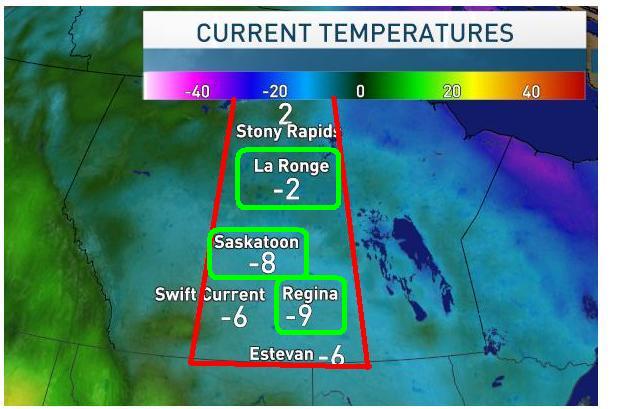
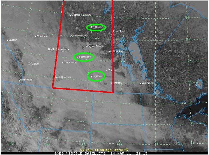
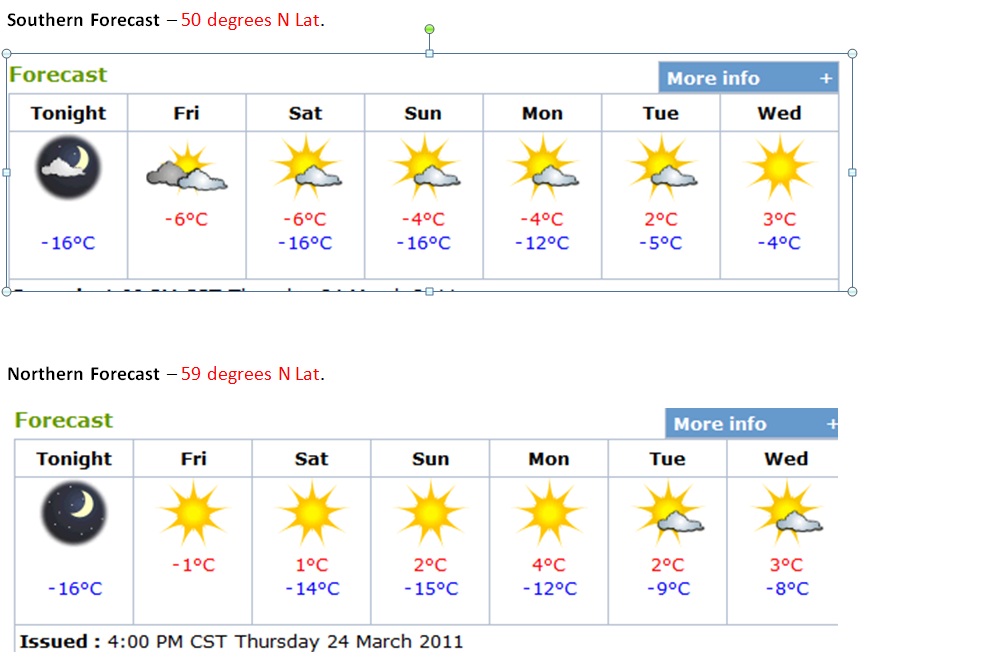
Here is a perfect example of how the coniferous forest influences temps. See attached pictures from Mar 24 on a basically clear calm day in the entire province. The area of warmer temps in the north of our province corresponds nicely with the forest cover easily seen in the satellite photo. The white that shows up in the south is snow pack with only a few wispy clouds.
It does require fairly specific conditions to be in place like is occurring this week. Clear skies, light winds and a homogeneous air mass over the entire province. Prior to March 1 the sun is too low to have much impact and after April 1 the snowpack is generally gone in the south. So March is definitely the most likely time for this to occur.
Today in Northern New Hampshire it’s 18.8 F and we are getting enough snow melt to notice. The sun is getting higher, we are having snow showers and a mix of sun and clouds. We also picked up almost 6 inches of Upslope snow over night.
I’m still studying snow albedo issues, and found some research on line about the topic of coniferous forests and other land types’ effects on albedo of snow cover. It’s starting to look like the “forest effect” is even greater than what I’ve allowed for in the new evergreen forest setting.
Meanwhile, I have a question. I’ve had some feedback from far northern areas that snow melt was too fast (even when using correct snow:water ratios). I need to know … if you ahve noticed this, was the snow exposed to full sunchine, or is it shaded by the trees part of the day? I’ve realized that one reason high temperatures may be being held down excessively over snow cover is if the melting is too fast. That melting, in WXSIM as in reality, takes energy that could otherwise be used to raise the temperature. If snow melt is slower in reality, then less energy was used to melt it, and was available for warming dark vegetation while the snow is relatively undisturbed in the shade.
The place where I measure my snow depth is quite sunny place but I think that the sun is in the shade about 3-4 hours a day. In winter we don’t have many days with proper sunlight so the sunlight doesn’t affect very much but now the situation is a little bit different because the sunlight has increased a lot. Amazingly the snow depth seems to be stuck in even if the solar power has increased clearly.
Now I’m using snow:water ratio 4 and wxsim is still forecasting too fast melting.
Last winter I did check up on the snow situation almost every day. I had a pole where there normally is an even snow layer often in the neighbourhood of 70-90 cm (2+ - 3 feet) at the peak of the snow situation). I melted snow every day I read (but in a slightly different place - not to interfere with the the area arounde the pole).
I am situated on a slope (1 meter per 20 average) in a south to southouteast direction. Only a few buildings within 100 meters (110 yards), and with coniferus forrest 200-400-600 meters away depending on direction - most free area to the soutsouteast.
I had a very good forecast on the snow melting (and to snow prrecipitation to - better than during rain season). The winter was much colder than normal in December and early January and average for the rest of the season, except for warmer than normal the last week or so. (BTW is there a statistical method that is the best for finding weather patterns, it looks like there are some periods of colder or warmer weather that comes back every year - I will post in another weather-watch forum!)
Unfortunately, I have not had time to recover that harddisk (cost of USD 1000) after a crash, nor had time to check the compressed backups. But in fact the snow melting prediction was so reliable that I moved to just a few measurements of water quota this winter, albeit to few, I found out that my brain invented the qouta too bad. I thought it was in the range of 4 when it was 1:2.1…
But last winter 2009/2010 I had a amazing result, snow melting within millimeters per day or better than 1/2 inch per week, mostly.
Thanks for the detailed feedback! I’m thinking that the too-fast forecast melting some users have seen may be due partly to trees shading the snow pack, though of course more feedback from other users would certainly help me determine this.
I do have a question: How were your temperature forecasts in the late winter/early spring? For some far-northern users, WXSIM has been forecasting too cold, especially for high temperatures, as the sun has “returned” over the snow pack.
During the winter of 2009/2010 I, and I recall Henkka/Weatherc (from Finland), reported some problems with erratic temperatures for some periods, or spurious/scattered days. That was thought by you to be because of the freezing of the Baltic Sea. The ice situation in the Baltic has been much worse this winter, i e the ice has been covering areas more south this year. This has made the icebreaking ships to be in high demand - coast line transports had to move over to lorries, when possible. So, one expected to see more of erratic temperatures this winter, but not so! The few erratic forecasts, when it comes to temperatures, has been when wind directions have been quite diffferent from what was expected. I haven’t had time to investigate why this happened, although I have briefly checked the weather data logged vs what actually happened and seen the difference, but has found no definate explanation. As you know, I am situated in the mid of the Scandinavian peninsula, as far from the Atlantic as I am from the Baltic, and that there are not too many METAR or other weather stations. Most of them being clustered in the Norwegian Atlantic coast around the Lofoten peninsula, or spread along the Swedish coast line of the Baltic. That is the East and West. To the North and to the South, there are even fewer weather stations mostly at small local airports, not having their own meterologists and where the airports are often only open for a few hours in the morning, then a few in the evening, and often closed during the weekends…
So, I expect most of any problems I have comes from lack of data to get into the WXSIM.
Perhaps the most significant change in my, almost always, manual forcasts from the previous winter, is a change from METAR to GFS for initial local data whenever I decide that there are too few stations with data (as said in my previous message, mainly when winds from the north or south). Otherwise I would lack data from stations within up to 400/500 km (250/300 miles)… That may explain some improvements in the temperature forecasts, or perhaps a better definition: getting rid of the worst temperature forecasts.