Who uses weather radar like the 88D and NEXRAD. Here is the number 1 best website www.weathertap.com just to let you know its not a free accessible site. To have access to the site its $6.95 per month or $73.95 yearly. Use money order, checks or credit card.
If you can pay $75.00 for WX Sim I know you can pay weathertap. This is the fastest and best radar on the net.
Not to be picky…OK maybe, but 88D and NEXRAD are one in the same. Both terms refer to the NWS doppler radar. With regards to Weathertap, it is a great service for NWS radar as well as satellite and other products. Recent enhancements have improved it as well. The radar data is timely and offers more of the derived products not found elsewhere. I’ve been a subscriber for about 5 years now. However, it does not…to my knowledge…offer uploading/publishing on your own web site and I think that’s what others on this forum are interested in. I may take a look at the GRlevel3 data one of these days as I’m impressed with the displays.
You must also remember that many 100’s or possibly 1000’s or users of WD are NOT in the USA, these sites may be the best thing available but they are totally useless unless you live in the USA!
Good point. I was curious as I checked the UK met office page and apparently there are 15 weather radars in the UK but the only images I could find online were “rainfall radar” images, similar to our precipitation estimates from NWS radars. Is there any way to purchase a radar subscription service in the UK similar to Weathertap in the US?
I believe there is nothing like that in the UK. Our Met Office are very careful who they allow to use their stuff and although I believe it can be bought it is I understand not cheap. Even most of the data I use for WXSim has to come from the USA as it gets published over there but not here - work that one out if you can #-o It is possible to get some images but usually they are quite old.
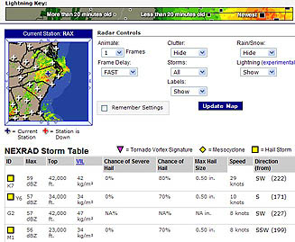
The 88D radar actually the current model we use but NEXRAD is a little upgrade of the radar that came about in 1996. This NEXRAD combined with 88D and the new tools that were added was lightning detector, mesocyclone and tornado detection.
I would be very careful with terminology. NOAA Radar does not detect tornados. It detects TVS or Tornado Vortex Signature… that is to say, a computer algorithm detects velocities in the air which indicate that a tornado vortex may have formed. However, in order for the vortex to be a tornado, it must extend to the ground… only spotters can determine this.
Indeed. The spotter network provides a wealth of information and a tremendous service to NWS warning operations. The next advancement in radar technology will the the implementation of dual polarization. More info can be found at:
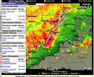
Weathertap is better because its the fastest weather on the web. In matter of fact I use to use to wunderground and I had many difficulties. The problems I encountered: images too slow, only load 6 images, lightning detector electrometer longwaves is too slow (picks up lightning strikes too late), radar goes down frequently, can’t adjust the radar animation speed and zoom in/out progress is too slow.
Weathertap I don’t encounter none of these problems because I pay for this quality of service. I will admit wunderground added a few more tools to the NEXRAD radar, but they need to improve the radar capabilities for better access.
I have found, at least for my area, that Wundergrounds radar products are incorrectly plotted on the maps. It’s incorrectly shifted approx 20 miles too far to the east.