GFS-maps & meteograms

First, was not sure to what category this fits best so Niko, feel free to move it if needed…

We like new toys, right? :slight_smile:

To do long story short…Since i saw the GFS-maps on Wetterzentrale i have had a small wish about doing own ones. Few days ago i runned over an another finnish wx-site who had did own maps and also some info about with what they are done. Soo…After a few days of reading, searching, much trial/errors i have get something out from it…

The magic app here is GrADS or OpenGrADS what i use. Its available for both UNIX- and Windows-systems, for free. Its not world most easiest app to setup but once it done, it will work automatic. Its pure commandline + textfile-based scripts and needs a x-server on the box (OpenGrADS is bundled with Xming x-server, also free).

One can create own scripts what include all needed commands so just one command is needed when runs it or just use ready-made scripts whats included in the package. One can create a map from almost all thinkable variables, there are 200+ to choose from in the gfs-files and they what still missing you can calculate :slight_smile:
Gfs-data is aviable in 3hr - ratio so there are 8 timesecvences per day to use, they are updated 4 times a day by NOAA’s superduper-puters at 00Z,06Z,12Z,18Z and are aviable about 4.5 hours later.

For more info:

I really suggest to read trought the pages and especially Documentation-section on GrADS site, it include also a list of all possible commands etc.

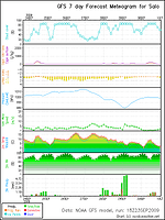
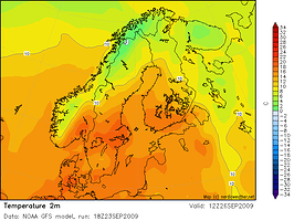
Attached two of my test-images i did, meteogram for my location and one map of the maps did. For the maps you get 8 maps for each day of forecast so ex. 72 hours gives 24 maps. There are 7 days of forecasts aviable.
I did a script where i create a set of 12 different maps (ex. temp,wind,Cape etc) for next 72 hours, this give me almost 300 maps, runned with just one command. This is runned with System-scheduler with a .bat-file and i have Fling-FTP to upload them to server. No page up yet, but will come on my site soon.

Also, when creating maps it downloads lots of data, my set of 12 maps for 72 hours downloaded 180 meg of data and it takes time, that set took about half an hour to do,so its need a dedicated wx-PC.

:smiley: :smiley:


Hi,

Any chance you want to share the scripts you use for this? :slight_smile:

/Chris

Nice one, I wondered how you created those on your site, thanks ever so much for the how to :slight_smile:
Sadly i aint got the foggiest as to what to do, its all irish to me :frowning:

Chris, you need to download a program thats link in weatherc’s post!

Yeah, I have the program. But you need scripts for the program to make those nice maps and animations. :slight_smile:

Ah, thats why i cant figure out diddly squat then pmsl…

Cute, playing with it, but this map takes only 10 seconds to generate (downloading data included)
I have a lot to learn and read, but it is interesting to learn how you can make your own maps.

Thanks for the links. :smiley: :smiley:


Since my first post have i moved the OpenGrads to run on the server as wx-stuff are runned from a dedicated box now :slight_smile:
And, the set of maps created every 6 hours has increased to 800+ :lol:

The script used for the maps are attached. Its runned with a command like this:

opengrads -lbxc 'run /path/to/nordic.gs 20100919 06

and when run it create all the forecastmaps seen on my page (the icemap and watertemp-map are created by other script)

For the animation…Its jQuery circle-plugin + some simple css whats used there :lol:

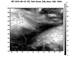
Pinto: would you share that colorcodes for that cloudmap? :slight_smile:

Henkka

run like:

gradsdap -lbc "run cld.gs 2010-09-18 12z 24"

I run it on windows XP

rename txt-file to cld.gs

so you have it all :slight_smile:

change longitude latitude in the gs file if you need :smiley:


cld.gs.txt (2.67 KB)

Hmm…i think you forgot to attach the script, if that’s what you meant. :slight_smile:

/Chris

Ahh…forgot that #-o
needs to renamed to .gs and other settings, like folder where to save image, coordinates for map (showing Nordic countries) etc.

Pinto, thanks :slight_smile:

henkka


nordic.gs.txt (38.3 KB)

Thanks a lot, you’re a star. :slight_smile:

Hi!

I’m trying to run the nordic script (I’ve done all changes needed-paths etc)), but I get the error:

Open Error: Can’t open description file
No Files Open

Pinto’s script runs fine!

Thanks!

Thanos

What I did was change:

*_baseurl = 'http://localhost:9090/dods/GFS_'hour'z'
baseurl = '/opt/gfsdata/'hour'/uwe.ctl'
*_dataset = 'gfs_hd/gfs_hd'date'/gfs_hd_'hour'z'
'open 'baseurl

to:

base= 'nomad1.ncep.noaa.gov:9090/dods'
'sdfopen http://' base '/gfs_master/gfs' date '/gfs_master_' hour 'z'

Thanks Criger, that did the trick! :smiley:

But now I get another error: Unknown Command: cbarm so I don’t get the column on the right part of the image!

Thanos

Ah, indeed. You can get it at: http://www.iges.org/grads/gadoc/library

/Chris

Thanks Chris, it’s ok now!

I have another issue with the plotted area for the map. Although I change the coordinates (latitude - longitude), the map either remains
the same or disappears at all! #-o Is there anything else to change except the coordinates to get the desired map?

I’m talking about the nordic script not pinto’s which is working if I change coordinates.

Thanks again for the help!

Thanos

For nps map:

view area

'set mpvals 0 37 54 71'

plot area


'set lon -60 100'
'set lat 43 90'

you are plotting your map but your view is set to Scandinavia, I guess

set mpvals lon-min lon-max lat-min lat-max

Thanks pinto! Now I can get maps from any area.

Is there a way to add another map with the 850 hPa temperature which is very important for the forecasts?

Thanks again!

Best regards,

Thanos

If the data is in the datafile ~> yes
else ~> no

Go to the data server you use and look at the info file.

Hi guys,
i’ve re-opened this discussion because i need your help Smile
I’ve installed grads software and i’ve created a script like this:

gradsdap -lbc "run cld.gs 2011-02-28 18z 24"

I’ve also download the pinto’s script. (thanks!)
The question:
How do you do to download the fresh GFS image?
The script above has a specific day …how to change it day by day?
Regards,

Alessandro