Now that the Weather Station and WxSim Location maps are up and running I was wondering what other maps could be created?
I wondered if a map of WeatherCams might be interesting? I know that many weather station web sites have cameras, but if you specifically wanted to find WeatherCams in an area/region you’d need to click on each site then possibly have to navigate through menus to find the cam(s). A map of links to WeatherCam pages would make it easier to find them. Just a thought…if people agree that it would be useful then it doesn’t take much to create a new map.
Alternatively, if you can think of other maps that could be create that are related fairly closely to weather watching then please comment and it might be something I can add.
I like the idea of a weather cam map. This is an idea I’ve had associated with my work. We are looking at weather gaps for drones and other Unmanned Air Systems since most will not be operating from an airport with an official weather station, so we have been looking at non-Federal government weather station networks. I had incorrectly assumed that NOAA MADIS was capturing a majority of personal weather stations in their network, but it turns out MADIS has the smallest number of personal weather stations when compared to the likes of Davis, WeatherFlow Tempest, Acurite, Ambient, Ecowitt, etc. The issue is that there is not a one-stop-shop network for UAS operators. I’m still investigating, but wondering if people are not uploading to CWOP, which is where MADIS gets the data. All that said, it would be interesting to have a single map (network) of weather cams, which are a valuable resource for UAS.
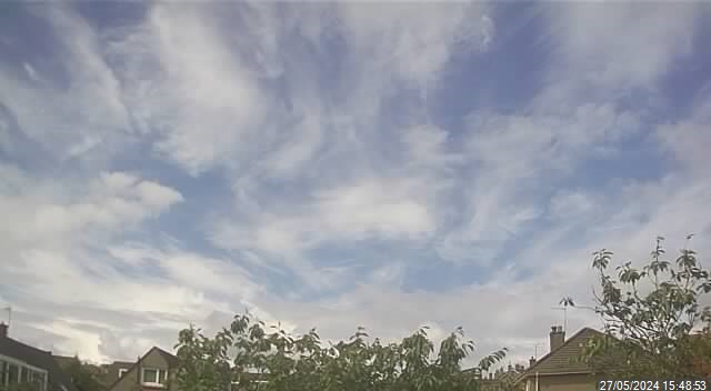
Webcams are good - “a picture is worth a thousand words” - but I am frequently frustrated because I have no idea of the direction the camera is pointing. . .
Mine points due north. I would like to point it south toward the Pentland Hills but there are also a few houses and electricity pylons in view, and the sun only climbs to 11° elevation at the winter solstice. But in the summer you can see sunset show on clouds almost due north. . . and I’m sure those of you that look at my webcam before I do at 09:00 will see similar at sunrise
I’ve started to create the map and wanted to pre-populate it with a few cams but have hit a problem. If I select a cam from a Saratoga template there’s a URL for the cam page - at least on a couple I looked at.
However, for pwsWD and Cumulusutils pages the cam view is selected ‘within’ the PHP/javaScript and there’s no specific URL for a page that displays the cam. So at best anyone wanting to see a cam will have to click on a link from the map and then a link/image on the template page to display the cam in a reasonable size.
No. . . but I presume the problem occurs because you are looking at websites to pre-populate the map with webcams? So it will go away when you allow people to add their own by adding a direct URL?
Your example works, but I was assuming that people would want visitors to go to a web page from their site that allowed (1) an animated cam image to be displayed (if there is one) and (2) gave visitors a link to the rest of the web site to have a look at the local conditions relating to the cam image.
That displays the image but as with @bitsostring’s example, it’s just an image with no link to your web site so no additional local weather condition info, etc.
Must admit my webcam doesn’t appear on the home page of my Saratoga template (…co.uk/ajax/), it’s in the drop-down menu under Live pages; and I removed the webcam link from the menu of my PWS Dashboard because it’s shown more or less full size if you click “Enlarge” on the dashboard itself.
Latest news is that it wasn’t a fire. Just orange netting flapping in the wind. Not easy to see from the ground when the netting is about 500 feet in the air.
I did wonder whether any of the appliances could work up enough pressure to get water up there. . . or maybe the Tower has a dry/wet riser with a dedicated pump for a sprinkler system.
'Elf & Safety at work . . .
P.S. I note from Wikipedia that “The top of the Tower caught fire in 1897, and the platform was seen on fire from up to 50 miles (80 km) away.”
Hi Chris, good idea.
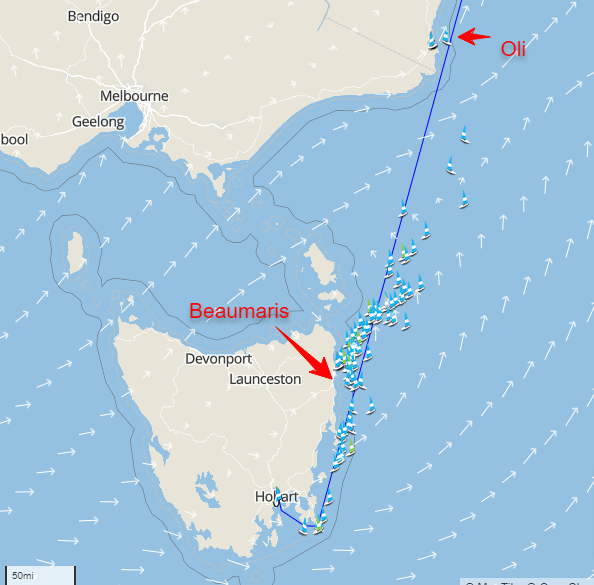
So I always upload a Thumb size and then many dif sized images with Weather Data overlays.
Here is the Thumbnail (meant for Map display) : https://beaumaris-weather.com/webcam/thumbnail1.jpg