When dnlding data in WXSIMATE, I often recv ‘Not Responding’ during GFS/MOS retrieval/culling. I switch site, click on it, and still same.
I just ran autorun and out of the 30 or so GFS scan windows, only 2 showed ‘found’.
We’ve found the problem!!! ![]()
There’s no way you had 52 inches of rain in the last 30 days! If you had, those temperatures might actually have been about right!
The question is now simply how such values are getting in there. My guess is that somewhere, millimeters are set as the units instead of inches. I bet it’s in WXSIMATE, under customize. You have to check the units both for display in WXSIMATE and for what is being used in WD log files. This could totally explain the problem.
Regarding advection, when MOS runs out, let it do the regional data advection with GFS. In auto run, it will go looking for GFS by default. In manual mode, I think you have to tell it to use that.
Tom
Unfortunately, both have " checked.
When I change to mm for both precip settings, re-dwnld, still 52". I closed, restarted, re-selected “, re-dwnld, still 52”.
Hi Lee,
Can you send me your 122009lg.txt and 12009lg.txt files? I need to see where this 52 inches of rain is coming from!
Tom
Sorry - make that 122009lg.txt and 12010lg.txt! ![]()
Tom
Off and away.
Tom I am interested in what you are saying about rain affecting forecasts. We had snow here recently and not having a heated rain gauge I allowed the snow to melt when temps allowed it. This has caused a spike in rain to 290mm or so in one day when all the snow melted. I now see my forecast temps some 8 degrees or so higher than our UKMO for Wednesday for example.
If this is the case how do we go about resolving this, since it seems reasonable that snow melt be included in the precip totals but it looks like it can confused WXSim? Or have I got it completely wrong?
Stuart
After talking w/ Tom about my log file having bad rain data for this calc, I would recommend either not using ‘recent precip’ if being used, or manually entering the 30 day value minus the melt-off. The only problem is I don’t know if the ‘snow/ice cover’ will compensate also.
Can you run a model w/out 'recent precip?
My lows are now significantly lower; and correct.
I have tried two things, first I ran an auto forecast with enforce monotone fit which brought down the temps a bit, then I turned off recent precip and reran an auto forecast and again things looked better. All this was with the same input data.
Bear in mind I am in the UK and have quite a micro climate for even the UK being very close to sea to the E and N. Also right now we dont have any laying snow or ice, its all gone (hence the large snow melt).
It was when I saw the speculation about rain amounts it made me wonder. My next auto forecast has run and I think the temps 5 days out are still a bit high even with no recent precip and monotone being set, the additional factor here is that my temps have in the past come out rather high on occasions. My current forecast predicts 11 degC for the high on Sturday but the UKMO says 4 degC!
Stuart
This is an interesting topic, and this is the first time I recall it coming up on the forum.
Lee’s problem appears to have resulted from garbled data in the WD log file. Haviong looked at many log files, this is the first time I had noticed such problems. They included yearly totals DECREASING each day (which makes no sense), and rainlastmin 25.4 times greater than the last hour, etc. This resulted in absurdly high rain totals and therefore bad forecasts.
The type of error one would tend to see in WXSIM with excessive rain (last day, week, and month) would be a greatly reduced diurnal temperature range and a tendency towards annual and seasonal normal temperatures. For instance, too warm in winter and too cool in summer, and too warm in cold spells and too cool in warm spells.
Usually, something like snow melt causing a spike would prodcue only modest errors. After all, at least the precipitation is real! The timing is off, though, as precip the last day counts more than the same amount earlier. I doubt it would often throw things off more than a degree or two, but it’s worth checking.
Tom
Tom thanks for the clarification. Still getting temps too high, or at least significantly higher than UKMO is predicting at present. I think for now I’ll wait and see how it goes and what the actuals end up as.
Stuart
Well My Highs are getting worse instead of better. I am sure its pry user error but I need to figure this out
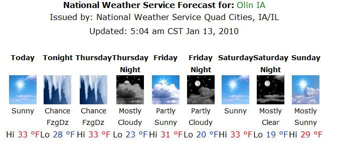
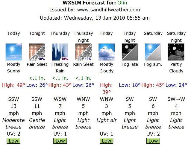
today the NWS says 32 as does all the local meda WXSim says 49 (I wish WXsim was right!)
My overnight lows seam to be right on the money but daytime highs are way to high especially the first day or 2
I unchecked recent percipatation and it dropped the forecast 1 degree
The news just said we would be 60 without the snowcover (but I have that manually entered)
Tom is there a file I could send you ?
Thanks all
Brad

Hi Brad,
Two questions:
(1) Are you inputting snow cover (depth and water content description)?
(2) Are you using Recent Temperatures?
Let me know the answers to that and we can take it from there.
Tom
Yes and yes I have roughly 10 inches of dry fluffy snow on ground. Liguid water ratio is 20.7
Todays high was 36.1
Thanks!
Brad
It is strange to have it hit 49 with 10 inche of snow. If you can send me wdata.txt, latest.wxf, custinit.txt, 122009lg.txt, and 12010lg.txt I can give it a try.
Tom
Just thought I would add is sometimes a user has to be as smart as program! For the time being I was 14 degrees to high daily until I was smart enough to enter the hazy condition . after I did that forecast looks right on the money!
I need to learn to pay more ATTENTION to what I am doing!
Thanks for all your help Tom
Brad
