Yeah, but they are talking about “only” 30 ft of the 770 ft total. Fortunately the suggested spillway collapse time has passed and things are getting easier so they may have dodged the bullet ![]()
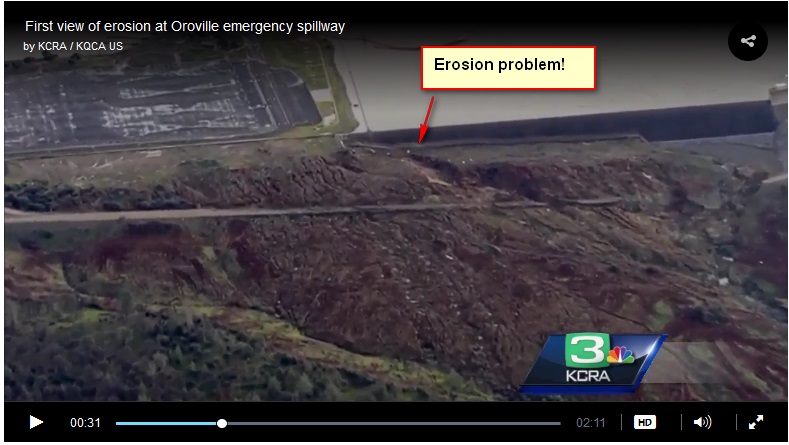
Originally linked video has been taken down so here’s a picture. A = regular spillway, this one is controlled but is also the one that started breaking up earlier this week. B = emergency spillway, this is just a low point in the dam with a 30 foot concrete lip. Concern is that the water pouring over it has eroded whatever the concrete is built on (apparently not much) and it is being undermined. Interesting to me is the water flowing at C which appears to be coming out of the hillside with no obvious source, that can’t be good.

…and just for laughs this article shows what that lake looked like in August 2014 8O http://www.nbcnews.com/storyline/california-drought/california-drought-crisis-takes-toll-lake-oroville-n185001
Wow, just been reading this in the news 8O
Quick status this AM. Lake level lowered = water no longer flowing over emergency spillway. National Guard preparing to dump bags of rocks from helicopter to reinforce spillway.
The dam itself is higher than the spillway and uninvolved (pic courtesy of KRCR TV).

In the meantime, another problem has come up elsewhere that I don’t believe is related to the Oroville problem.
[quote][size=10pt][size=12pt]This is an Evacuation Notice from Sacramento County Office of Emergency Services. Tyler Island is expected to flood due to a compromised levee. Residents are strongly advised to leave the area for their safety. Safe travel routes include Tyler Island Road south to Tyler Island Bridge Road and then to River Road either north or south. Residents can also use Tyler Island / San Andrus Island Road north to Walnut Grove Road and then north or south to either River Road or West Walnut Grove Road. Residents may obtain additional road closure information from 3-1-1.
The emergency spillway erosion damage was visible this morning. They’re planning on dropping sacks of rocks from helicopters to shore up the erosion area so they’ll be able to use that spillway if needed in the future. Meanwhile, they’re draining (over the damaged main spillway) 100Kcfs while the lake is receiving 45Kcfs of inflow. The lake level has dropped below the emergency spillway and they’re hoping to drain the lake down 30ft in prep for the next storms to arrive Wed/Thurs this week.
edit: corrected ‘cfm’ to the correct ‘cfs’ measurement, thanks to Niko.
Good capture Ken.
I believe it’s cfs not cfm.
D’Oh… factor of 60 is outside engineering tolerances… yes, it’s cfs … thanks Niko.
It’s staggering volume of water 8O You’re excused :lol:
Who in the world approved an earthen emergency spillway. Even I know what moving water does to dirt?? 8O
So, the main spillway, someone wasn’t inspecting it regularly to catch the reason for the erosion to occur?
Busy armchair engineer here, 100% guaranteed pure speculation on my part :lol:
According to this article the exact issue came up 12 years ago when the dam was re-licensed. When the various officials have been asked on TV about this 2005 report it’s been like watching the three monkeys, no one admits to having seen it.
Looking at the pictures, and diagrams, and the DWR’s panic about erosion it appears to me that the emergency spillway wall doesn’t have anything like the kind of foundation that I would expect for a “mini-dam”.
So, the main spillway, someone wasn't inspecting it regularly to catch the reason for the erosion to occur?
They fixed some cracks in that area (apparently with some kind of grout/caulk) a few years ago, and inspected it remotely a couple of years ago. Talking to my neighbor this morning we agreed that neither of us had seen any sign of rebar in the concrete floor of the spillway. With broken concrete like this wouldn’t you expect to see the rebar?
I think the erosion problem with the emergency spillway is actually at the other end, nearest the normal spillway. There is a section of erosion that worked it’s way back under the emergency spillway and caused the evacuation order. While a failure at the other end of the emergency spillway would have been a problem, the amount of water at the point near the parking lot would not have been 30’ tall. So far I have not heard any reports on how they plan to repair the portion of the erosion under the emergency spillway. I fear the storms expected Wed/Thu will make matters much worse as the lake level rises and puts more pressure on the spillway.
Agreed. They’ve been dumping a lot of rock+slurry at the normal spillway end. But there are some holes that appear to be very deep in various places. Hopefully they can take the water level low enough that the coming storm won’t be an issue.
I can’t find the quote now but a water & power guy said that a small flow of water can cause more erosion than a really gully washer :-k
Remotely? 8O 8O
Heck yeah, there would be rebar all over the place, especially since the rebar should either be tied or welded together at each junction.
I’m no dam expert, ha, but I’ve seen a few in my day, and I would expect a wider spillway on such a large lake.
Wonder if the concrete was even tested as it was poured back then, doubtful. Then did someone decide to add more water to the mix as it was being poured, and weakened it. Ugh, Government at work always give me heartburn.
Big rain coming. Atmospheric river forecast for Monday, targeted right at the Oroville dam area (yellow arrow).

8O 8O 8O
Alltime low baro today: 29.14 in (986.8 mb) and still falling. No wonder it was so windy. A lot of trees and powerlines down throughout the CWA.